Skydio 3D Scan – A powerful 3D Mapping Software ruling the world
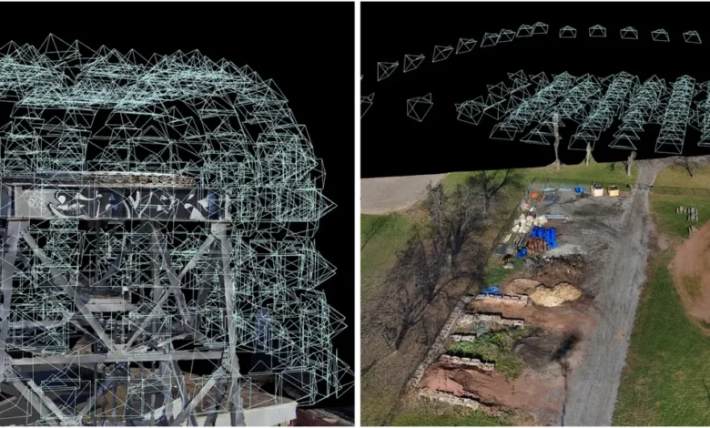
Skydio 3D Scan, built by Skydio Autonomy Enterprise, can carry out the most complex and challenging inspections at a faster rate with the best pilot training. This first-of-its-kind adaptive scanning software aids the drone in automating data capture processes to generate 3D models with comprehensive coverage and high-quality resolution.
Generally, 3D models functioning on manual drones require even skilled pilots to fly far away from the inspection objects to avoid collisions while gathering the necessary data. However, this 3D scan breaks the legacy. The results based on beta customers for Close Proximity Obstacle Avoidance show that Skydio 3D scan offers up to a 30% lesser Reinspection Rate. Hence, delivering the pilots a safe flight.
Additionally, this 3D scan not only enhances the speed of data capture by 75% but also reduces the Data Capture Hardware Cost by 50%, making it cheap and affordable. Moreover, its Edge Model Viewer provides rapid in-field assessments to capture 3D reports with high-fidelity inspection of complex 2D structures, enabling robust wide area mapping, making this autonomous drone unique in the market. Try out this incredibly impressive drone today!
Read on to know some of its outstanding features in detail.
Simpler Visual Geo-fencing
Skydio 3D Scan offers simple and well-to-do Visual Geo-fencing features that help scan the defined boundaries by the user quickly. This drone technique delivers the data with better precision than the GPS-based methods by recognizing boundaries, thus reducing the ground risk. With this incredible feature, you can adapt to the large volumes of crowded areas, bridges, and highways.
Faster Multi-Battery Scans
Skydio 3D Scan helps us to visually understand and relocate the area for making a 3D model through the computer. You can make a 3D model of the area without using GPS. This alternative helps save energy, time, and power as it does not collect redundant data from multiple sources, which slows down 3D reconstruction.
Excellent Real-time AR Coverage
You, as a user, can capture a real-time AR or augmented reality view of the scanned surfaces. This unique feature of Skydio 3D scan allows the operators to recognize and snap the gaps. You can also track the progress of the scan from time to time. As a result, it validates the task completion, thereby reducing the re-fly rate to ensure complete and accurate coverage.
Compatible AR Observer
This feature enables the operator to view the location of a particular place. Moreover, they can navigate the surrounding area and click its 3D views with the help of the Skydio 3D Scan. Plus point, the normal GPS can neither track nor find the drone’s location, thus providing safety to the operator.
How to use the Skydio 3D Scan?
The Scan Setup
Firstly, choose the required capture modes you need using Skydio 3D Scan. Moving on, carry out the on-screen workflows. Then, get started with the autonomous 2D or 3D scan
Start Scanning
Secondly, the Skydio 3D scan drone flies, collects the data and starts scanning the real-time information with the help of the AR Coverage and AR Observer features.
Look For The Available Data On-site
As an operator of Skydio 3D Scan, you can assess data quickly using the Edge Model Viewer and instantly capture the scanned scene.
Generate High-Quality 3D Models Instantly
With the help of the Skydio 3D Scan, Operators or users can get the 3D data of the structured surface from any angle by covering the ultra-quality 3D views offering maximum safety to the pilots. Also, they can generate 2D planar flying patterns with minimal obstacles.
Why choose the Skydio 3D Scan?
It is an excellent invention of modern times. With this drone, operators can easily construct the 3D model of the structure, scenes, or assets. In addition, it can capture the subjects’ images in close proximity, giving it speed and accuracy while collecting better quality data.
Moreover, the drone helps gather data for mapping the location and assists in capturing the structures of the building. This makes it a perfect 3D model in the present time and hence will prove to be your best choice.
Follow Dronephi on Twitter, Facebook, Instagram, and LinkedIn, or join on Telegram channel for all the latest updates on FPV, Drone Tech, Military Drones, Drone Related News, and more!
